Showing posts with label Better Know a City. Show all posts

Wednesday, February 15, 2017

The 34 Most Beautiful Places in Oita Prefecture, Japan

So, the other day I was checking CNN's website, and I saw this article:

Japan's 34 most beautiful places

Side note: Why 34?  Why not 26 or 42?  Apparently lists of 34 are a thing now?  A google search for "34 most" shows that a lot of people are counting to 34 now on their listicles.  Does anyone know why?  Was this some meme I missed?

Anyway, back to the point...

"Hmm," I thought.  "I sure saw a lot of beautiful stuff in Oita prefecture.  I wonder if any of that made their list."

So, I checked it out, and sure enough, there were 2 entries from Oita prefecture on CNN's list: the Kintestu Beppu Ropeway (at number 6) and Usa Shrine (at number 14).

Now, don't get me wrong, I like both the Kintestu Beppu Ropeway and Usa Shrine.  Beppu, as a city, certainly has its charms, and Usa Shrine is tremendously historically and culturally important.  But I wouldn't particularly put them on a list of the 34 most beautiful places in Japan.  They wouldn't even make my list of the 34 most beautiful places in Oita prefecture.

So, I decided to go through the photos on my blog archives and come up with my own list of the 34 most beautiful places in Oita prefecture.
I've done my best to rank these in order.  (Number 1 is the most beautiful, and they gradually get less impressive from there.)  Of course the standard disclaimers for any sort of subjective list apply. These are just my personal feelings, and other people will take different views. And, to the extent that one's own personal feelings are difficult to quantify, and given that feelings are inherently unstable and change from day-to-day, I'm not even sure it's a perfect reflection of that.
In addition to the standard disclaimers, I've got 4 more special disclaimers for this list.

Disclaimer 1: Unfortunately, I never got around to visiting all of Oita prefecture, so this list unfortunately omits Kamitsue-Mura, Notsuhara-Machi, Hasama-Machi, Shonai Machi, Ogi-Machi, Kuju-Machi, Naoiri-Machi, Kiyokawa Mura, Asaji-Machi, Ono-Machi, Chitose-Machi, Inukai-Machi, Nostu-Machi, Yayoi-Machi, Honjo-Mura, Ume-Machi, and Naokawa-Mura.
If anyone is reading this from any of those towns, let me know what I missed in the comments.

Disclaimer 2: Because these lists work best as visuals, I'm only going to include what I have photos for.  Any descriptions that are only in written form aren't included on this list.
I am, however, giving myself some lee-way on the quality of my photos.  There are, for example, some really beautiful places in Oita prefecture that I didn't quite do justice on film--sometimes because the flat screen can't really capture how impressive these sprawling landscapes are in real life.  Other times because I took my photos at the wrong time of year.  (Most of these places look most beautiful in spring and summer, when all the vegetation is in full bloom.  But unfortunately several of these photos I took during the winter).
In these cases, I'm just going to post my photo, and then make a short disclaimer about how the photo doesn't really do it justice.

Disclaimer 3: Related to disclaimer 2, the camera I used back in 2007-2009 was never really top of the line, even at the time.  But technology has moved on now so that these pictures look embarrassingly low-resolution compared to the average picture you see on Facebook these days.  But these pictures are what I've got, so these are what I'm using.
That being said, to see these pictures in their full resolution (for whatever that may or may not be worth) click the pictures to see the enlarged version.  (But of course you already knew that, you technical person you.)

Disclaimer 4: In order to keep this post from getting cluttered, I've limited myself to only one photo per place.  In cases where one photo doesn't quite do the place justice, I've included links to my other photos in the text description.

1. Sora no Koen (sky park) in Yonozu


This picture doesn't do it justice, because the view is really best experienced in 360 degrees--standing up on the hilltop, and seeing all the wide blue ocean and mountains laid out before you was breathtaking.

2. Harajiri Waterfall in Ogata Town


Again, a picture doesn't really do it justice.  It's a horse-shoe shaped waterfall, so you really have to see it from all 3 sides (something I couldn't capture in this picture).  Also, this picture is from fall, but to see the Waterfall at its fullest, it's best to go in spring just after the rainy season--see here.

3. Ryumon Waterfall in Kusu (Or possibly in Kokonoe.  I got a bit confused on the exact town boarders with this one.)


This picture isn't bad, but it doesn't get all the angles.  To see the pool at the top, look here.  For the view looking down, see here.

4.  Higashishiya Waterfall in Ajimu


At the risk of becoming a broken record, once again the picture doesn't really do it justice.  You have to see it up close to appreciate how big and magnificent it is.

5. Fukino Waterfall in Ajimu


This picture was taken at the lookout point, overlooking Fukino Waterfall.  But you can also walk up to the base of the waterfall, and get some great views from there as well--see here for example.

6. The view from the Road leading to Hatozu Beach in Kamae Town


There are tons of great views like this along the Southern part of Oita prefecture of the mountains running into the ocean.

7. Seaside Temple on Himeshima Island


The actual temple is not so impressive, but the seaside around it is amazing.  Unfortunately I couldn't capture all this one one photo, but see here for the view to the left of this temple.  

8.  Aoi No Domo in Honyabakei


This is a view from the cliffs of the valley below.  A view of the river below the cliffs can be seen here.  I regret to say I never got a good picture of the cliffs themselves.  

9. Taikkiri Valley in Innai


A beautiful little walk down a lovely little river.  It culminates with a view of a Waterfall, which you can view from the top looking down.  (Or at least, you can view it if you ignore the safety signs).  See here for the waterfall at the end.

10. Waterfall in Yabekei


If I ever knew the name of this particularly waterfall, I've forgotten it.  (We always just called it the "Yabakei Waterfall" during my days.)  The river leading down to this waterfall is quite beautiful as well.  See here.  

11. The view of the rivers in Yufuin


The peaceful rivers in the town of Yufuin can be very beautiful, especially during Cherry Blossom season.

12. Fukami Valley in Ajimu


There are a lot of beautiful valleys in Oita Prefecture, but this is one of my favorites.  You can see the rice fields along the valley carved in like steps.  See here for a better view of the terraced rice fields.

13. Sakura Waterfall in Amagase


This is just off the road from a small charming faux-Bavarian bath house town on the river.  See here for pictures of that town.

14. 3 Day Moon Waterfall in Kusu
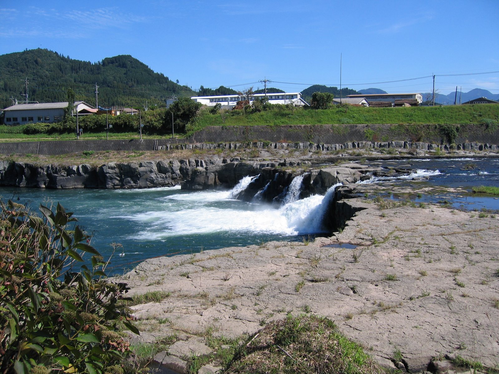

For the view from the front of the waterfall, see here.

15.  Kamidozaki Natural park and look out point in Kamiura


For the view from the left side, see here.

16.  Monkey Jumping Point in Yamakuni


Another place where the pictures don't really do it justice.  But when the river is full after rainy season, this river turns into an impressive rapids between these big rocks.

17. Jion Waterfall in Kusu (or possibly in Amagase--the map was a bit confusing)


18. Peace Park on Mount Hachiman in Sanko Mura


The picture doesn't really do it justice, but this is a beautiful example of a Japanese garden built into a mountain slope.  So as you keep climbing up, you keep seeing more and more of the garden.
It's hard to really capture all the views of Mount Hachiman in one picture.  For more pictures, see the Sanko Mura post.

19.  Kanarase Mountain Hike in Innai


The picture doesn't do it justice.  In part because it's hard to summarize a 3 hour hike in one photo.  (For more photos, see my post on Innai.)  And also, because I took this photo at the wrong time of year, in November, when most of the foliage had died for the winter.  To see this in its full glory, go in late spring.

20. Kyusuikei Gorge in Kokonoe


The famous bridge in Kokonoe is just a tourist trap, but the views of the Kyusuikei Gorge leading up to it are absolutely gorgeous.  Also a beautiful little waterfall is on the road going up this gorge--see here.

21. Nokogiri Mountain Hike in Yamaga


This is another hike that goes on for a long time, and is impossible to completely capture in one photo.  For more photos, see my post on Yamaga.

22. Asahidai scenic overlook in Kokonoe


Kokonoe is filled with these gorgeous views of long flat stretches of land with mountains in the background.  The static image of the camera doesn't really do justice to the beautiful long stretches of road.  The road through the Handa plateau in Kokonoe is actually probably more impressive than the Asahidai scenic overlook when you drive through it in person, but the Asahidai scenic overlook comes out better on film, so I'm putting it up here.  (For a picture of the Handa plateau, though, see here.)  

23. Oka Castle in Taketa


The ruins of an old castle, now covered with grass and cherry blossom trees.

24. Sento Mountain Hike in Kunimi


This is another long hike that is impossible to summarize in one picture.  For more pictures from this hike, see my post on Kunimi.  For a great view from the top of the mountain, see here.

25. Yamakuni River in Yabakei


This picture is from Yabakei, but the whole stretch of road following the Yamakuni river also includes Honyabakei and Yamakuni town.  It's a beautiful drive following a river valley winding its way between the mountains.  (This picture doesn't do it justice, first of all because it's a very long river that can't be captured in one photo, secondly because the foliage was not yet in full bloom on the mountains when I took it.)

26. Kirikabu Mountain in Kusu


This is the view from the top of Kirikabu looking down.  For a view of the mountain from the ground, see here.  

27. Takahira Park Look Out Point in Kamae
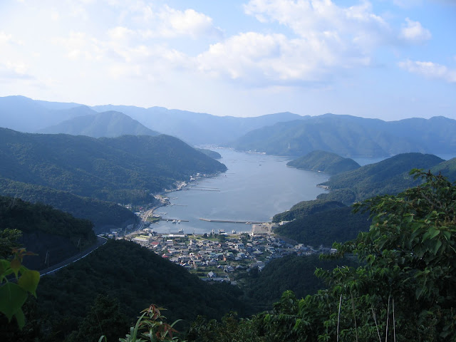

This picture doesn't capture the full 360 view, so also see here and here.  

28. Mount Yufu in Yufuin (also on the border with Beppu)


This is the view looking up the mountain.  For a view looking down at the town below, see here.  

29. Hita River in Hita


Perhaps to fully appreciate, you need to see it at night when it's all decorated with paper lanterns.  Also, although this picture is off the main downtown stretch, the most beautiful parts of the river are just slightly downstream, here and here.

30. View of the Ocean from Tagauraenchi Peace Park in Tsurumi


If some of these pictures are starting to get repetitive, it's because a lot of Southern Oita is nothing but mountains against the oceans.  But I never complained.  The sight of those lush green mountains against the deep blue ocean always looked beautiful to me.

31. The rice fields in the valley of Ogata


I was fortunate enough to catch Ogata on a beautiful sunny summer day when I went down there.  But in addition to its beautiful waterfall, Ogata also has gorgeous green rice fields carved into the valley.  See also this picture here.  

32.  Futago Shrine in Kunisaki (or possibly in Bungo Takeda--the border is unclear).


A beautiful shrine in the middle of a mountain forest.

33. Sen no Iwa in Ajimu


Unfortunately I totally took these pictures at the wrong time of year.  But on a spring day this area looks a lot greener and sunnier, and these rock formations are really cool.  For a view from the top, see here.  

34. Kakaji Mountain in Kakaji


Another long hike that is impossible to capture in one photo.  For more photos see my post on Kakaji.  Also, although this was my first and only trip to Kakaji mountain, I'm relatively sure this must have looked more beautiful in the spring when all the foliage was in bloom. 

Link of the Day

Friday, February 12, 2010

Better Know A City: Reflections

Having left Oita Prefecture now, I'm going to have to leave this project half finished. (I completed 41 different towns (see index for a complete list), but I still had 17 left to go.)

One never knows what the future holds. It is possible in a few years I might someday find myself back in the area, and I might someday yet finish this project up. But for now, I'm stopping.

Even without finishing, I still completed 41 different cities on this project. And now I'm a little unsure if this represents an accomplishment to be proud of, or an eccentricity to apologize for.

It was no doubt a heavy investment in time. Each one of those 41 cities was a whole day in itself. As I got farther and farther away from my home base in Nakatsu, driving time reached as much as 3 hours each way. And sorting through my maps, notes, pictures and video afterwards often took the better part of a second day.

And yet, the project had its rewards as well. When I felt the sun shining on my back, or smelled the ocean, or felt the wind on my face, or saw the view from a mountain, I often felt like it was the most alive I had felt all week, and that I was living life to the fullest.
The appeal of exploring a new area, or hiking around outdoors, is perhaps something that can't be explained to the uninitiated. If you enjoy sight-seeing, than you don't need me to explain its appeal to you. On the other hand, if you dislike it, I'm not sure I could explain why I do it.

And for what it's worth, I also saw some truly breathtaking areas of beauty, that I most likely would never have seen otherwise.

But this only explains half of my eccentricity. I suppose the next question is: given what a headache it is to sort through notes, photos, and videos, why do a blog post on each city? Why not just hike around in it and call it good?
Well, as I said when I first started this project, after years of wandering around Japan aimlessly, I wanted to give my expeditions a bit more structure and purpose. And I enjoyed keeping a record of where I had gone and what I had done.

Journalling, like hiking, perhaps can not be explained to the uniniated. If you suffer from the same compulsion, I'm sure you already know what I'm talking about. Otherwise it's probably useless to try and explain it further.

This was a project I undertook to challenge myself, and to keep myself intellectually occupied after I had stayed in Japan way too long, and was in danger of getting bored.

Therefore this is something I did primarily for my own benefit, and if it doesn't entirely make sense to anyone else, that's OK.

Although I suppose I would be lying if I said there weren't times when I was trying to engage other people.

Blogging is sometimes a bit ambigous that way.
All private journals are written for the writers benefit. All published works are written for the reader's benefit. Blogging, at least the sort of blogging I do, walks an awkward line in between. There were times when I was writing about wrong turns I took on back country roads not so much because I thought it would be interesting to someone else, but because I was trying to keep a thorough record for my own benefit.

However, especially once I added pictures and videos to this blog, there were times when I went out of my way to get pictures of an area because I wanted other people to be able to see what I had seen.

The idea that I was filling a blogging niche on the less-travelled road of Oita prefecture also appealed to me. Although there is very little truly virgin ground left on the internet these days. Just about every place I wrote about or photographed is already up on the Internet somewhere. (And that is why I often included links to other webpages at the bottom of each post-- to acknowledge people who had written about these areas before me).

Even though I get no sort of benefit from documenting every city in Oita prefecture, now that I've gotten started the anal rententive part of me really hates to leave this project half finished. So I'm leaving the door open for the possibility that I might someday return to finish it, should the fancy strike me (In a couple years, or 5, or 10, or maybe 15).

To that end, here is a list of the remaining 17 towns I never got around to.

In Hita district
1. Kamitsue-Mura

In Oita district
2. Notsuhara-Machi

In Yufu district
3. Hasama-Machi
4. Shonai Machi

In Taketa district
5. Ogi-Machi
6. Kuju-Machi
7. Naoiri-Machi

In Bungo Ono District
8. Kiyokawa Mura
9. Asaji-Machi
10. Ono-Machi
11. Chitose-Machi
12. Inukai-Machi

In Usuki Distric
13. Nostu-Machi

In Saiki City
14. Yayoi-Machi
15. Honjo-Mura
16. Ume-Machi
17. Naokawa-Mura

If I want to get even more anal-retentive about this, I should add the first few towns I did don't have any pictures or video to go along with them. So I should probably redo Nakatsu, Usa, Bungo-Takeda and Sanko-Mura. (Even though I did later add some additions to Usa and additions to Nakatsu, neither of those were very thorough. In Nakatsu in particular I never got the main part of the city.)

I never had video for my post on Matama. And I didn't have good definition photographs for my post on Kitsuki. Although probably both of those posts are adequate as they are.

I did a real poor job on Oita city (stayed entirely within a small radius from the station, and was inside most of that time.) That might be flagged for a redo.

And if you really want to get picky, during the grey months of winter the towns were all drab. So I was unable to capture the beauty of any of the towns I did in the winter months (Yamaga, Kakaji, Hiji, and Kitsuki (again)...and perhaps Ajimu, which is unfortunate because this was my home as a JET. It's actually a very beautiful place, although you wouldn't necessarily know that from my blog post.)

Link of the Day
Chomsky on Geithner

Thursday, February 11, 2010

Nakatsue Village / 中津江村

(Better Know a City)

[Editor's note: this is the last "Better Know a City" trip I did before I got really burned out on the whole thing. As a result, it has been about 6 months between when I originally toured Nakatsue, and the time it has taken me to write up this post. Obviously the memory gets a little faulty after 6 months. Certain parts of this may not be lacking in detail where the memory gets a little hazy, but hopefully the pictures and video will make up for what this post may lack in description. After sorting through my old notes, I'm reasonably sure I got all the photos in the right places. Anyone who notices an error can feel free to correct me in the comments section.
And, this is it. This is my last "Better Know a City" entry.]

Monday, September 21, 2009
For a long time, I would always get Nakatsue Village and Nakatsu city mixed up. Aside from the little "e" at the end, they're spelled almost exactly the same, and the pronunciation is just as similar. It's just asking for confusion to have two towns in the same prefecture with such similar names. But no one consulted me when they were naming these towns.

Nakatsue Village is located close to Hita, and when I was staying in Hita and bored, I think I drove through it a couple of times.

Also way back during my first year on JET in the spring of 2002 I participated in the annual JET cycling ride. We cycled through Nakatsue Village, and spent the night at a Nakatsue campground. (Well, campground in the Japanese sense at least--meaning we stayed at a lodge rather than a hotel).

This was right when Japan was gearing up to host the 2002 World Cup. Nakatsue Village had been chosen, for some reason, to host the Cameroon soccer team. In fact, the campground where we were staying at was going to be where the Cameroon soccer team would stay and practice during the summer, and preparations for the Cameroon team's arrival were already underway. We were instructed to be on our best behaviour and not mess anything up.

Also already throughout Nakatsue village there were several signs up welcoming the Cameroon team. Many of these signs were written in French (apparently the national language of Cameroon).
Not all Japanese towns were given the privilege of hosting a soccer team, so the Cameroon team was Nakatsue's big claim to fame that year.
After the trip, when I got back to my office and mentioned we had stayed in Nakatsue there was first the usual confusion over weather I meant Nakatsu or Nakatsue. Then they immediately mentioned "Ah, the Cameroon soccer team."

7 years later, Nakatsue Village is still actively advertising its association with Cameroon, and you still see Cameroon's flag prominently displayed, and random signs written in French.

Driving down from Nakatsu city, Nakatsue Village was almost 2 hours away. I had to drive down to Hita first, then from Hita through Oyama before finally crossing over into Nakatsue Village.

Shortly after arriving, there was a dam (Shimouke dam) and a little park built around it (Hachisu Koen), so I stopped here to stretch my legs and take a few pictures.

There was a small information center for Shimouke dam where you could wander through and take pamphlets. So I tried to find as many pamphlets on Nakatsue as I could. (Because Nakatsue was a small village, there weren't many pamphlets just on Nakatsue itself, but there were a lot of pamphlets on the greater area.)

I walked around and taking some pictures (and interacting with a few children who wanted to practice their English on me).


There was a small cafe near the lake, and I stopped in to get a cup of coffee.


The cafe had lots of antique furniture there would could look at.

The woman there served me a free piece of banana cake as well. "We have extra banana cake," she explained. "Please, have a piece."

She also asked me if I was an artist. "Me? No, nothing of the sort," I responded.

"I thought I saw you drawing in your notebook outside," she said. And I explained that I had simply been writing down the names of the signs.
While I was drinking my coffee, a number of people were coming in and out of the cafe giving gifts, and the woman explained that this was because it was Respect for the Aged day (W).

After this, I set out to visit Taio no Kinzan (Taio goldmine). Taio Goldmine is the biggest attraction in Nakatsue-Mura, and they have signs for it from miles away. Driving through the Hita area, I've seen the signs a lot over the years, but for some reason never made it out to the goldmine.

I followed the signs, and drove to the goldmine. As I drove up the hill, the Cameron theme of Nakatsue-Mura became more and more apparent, and there were several signs in French.

Despite being located out in the middle of nowhere, the Taio Goldmine was incredibly busy. This was probably because I had visited during "Silver Week" (W). There were uniformed men directing the traffic who showed me where they wanted me to park. There were lots of motorcycles parked there (apparently a lot of people go touring on motorcycle during Silver Week). And the car license plates were from all over Japan. (Again, pretty impressive for a little tourist resort up in the middle of nowhere).


There was a big sign in the parking lot, proclaiming in big letters that Nakatsue-Mura was "the Switzerland of Asia." In smaller letters was written the explanation that the Cameroon ambassador had come to visit Nakatsue-Mura, and said it reminded him of his hometown. (And I guess the Cameroon ambassador must have had some Swiss connection. I don't know, maybe I read the sign wrong.)


There were several shops on the way to the goldmine. There was also a building where (for the price of admission) you could sift through the sands and look for gold yourself.
This seemed to be quite popular with people, but I passed it by. I wasn't sure what I was going to do with gold even if I found some.


I continued on towards the Taio Goldmine.
I was a little bit confused about where to buy the ticket once I got to the entrance, and when I finally found the ticket booth, they seemed almost reluctant to sell it to me. "It's 1,000 yen to go in. Are you sure?" the lady asked me.

Before getting to the actual goldmine, I had to walk through a couple non-related (as far as I could tell) exhibits, like a dinosaur exhibit. There was also a display indicating that the Mayor of Nakatsue (Yasumu Sakamoto) had been awarded the medal of the knights of Cameroon.

At the entrance to the actual Taio goldmine, they gave me a set of earphones. There was also a small box which hung from around my neck. As I walked through the Taio goldmine, the box was supposed to pick up the various radio signals, and broadcast the appropriate information into my ears. So I guess a free audio-tour is included in the price of admission.

I asked if they had an English version of the audio. They did not, but they did, however, give me a written English translation of the Japanese audio, running 12 pages.
--Which I never even read, so I guess it was kind of a waste of paper. The beginning starts out with:

Taiokinzan--Tour Guide Script
(Girl Voice): Welcome to the Underground Museum, Taiokinzan!
(Boy Voice): At Taiokinzan's prime, this serene locaction--a mountain covered by teh verdant foliage of ceder trees--reverberated with the joyfull cries of people who gathered here in search of gold.
(G): Now, this part of earth relives as "Underground Museum: Taiokinzan" and welcomes visitors like you.
The entire mine tunnel is approximately 1 kilometer, or 0.6 miles, long and is divided into nine areas. The tour will take about 40 minutes. The first half is a recreation of the mining process during the Showa period, and the second half is a recreation of the mining during the Edo period.
(B) Step one foot inside the mine tunnels and there you'll discover the surviving dreams and romantic sentiment of the "yama-otoko", or "mountain men"--the name give to mine workers in Japan.

And on it goes for 12 pages.

I dutifully wore the earphones at first, trying to gain every useful piece of information that I could. But after about 5 minutes, I decided I was sick of this extra noise in my ear, and just took them off.

Almost everyone else around me seemed to follow the same pattern. Everyone had the earphones on for the first five minutes or so, but everyone took them off after that.

There were a few things to see before entering the tunnel, like a water mill (complete with an English explanation).


And then I went through the tunnel, and I was in the cave.
As opposed to the hot weather outside, it was actually nice and cool inside the cave. It was a very pleasant way to spend an afternoon. (Although on the downside there were a lot of kids crying and yelling, and that sound reverberated off the walls of the cave. But this was probably worse than normal because it was a public holiday).

The place was, as advertised, essentially a museum underground. There were various mannequins in poses to illustrate what life was like for mine workers of that time. (Some of them were even primitive animatronics that moved a little bit).

For the most part, I'm going to let the videos and pictures speak for themselves, without recounting every single thing I saw in that cave. But it was pretty cool.


Just a couple quick notes: according to one sign (if I read it correctly) at one point there was a Japanese television drama about a mine worker, and parts of it were filmed in this cave. I thought that was kind of cool.

And one of the tunnels (although they had it blocked off) appeared to lead over to the neighboring town in Fukuoka prefecture.

And, despite many low hanging areas, I managed to somehow miraculously get through the whole place without banging my head once.

At the end of the gold mine there was, included in the price of admission, a museum dedicated to beetles. (Again, not sure what the connection is).

Historically, the goldmine had at one time been owned by an Englishman named Hans Hunter (maybe around the turn of the century or so) and according to the sign, to this day Nakatsue-Mura keeps up an exchange with mining towns in Wales.

After touring the mining areas, I went to the Taio Kinzan resturant to get some food. They were incredibly busy, but I managed to find a seat at the long bar facing the window.

I ordered the "Miner's Curry", and this took an eternity for them to get it to me. Fortunately I had a good book with me. (I was still chugging my way through "War and Peace" at the time). Just when I was about to give up and leave without my food, they came out with my Miner's Curry.

I'm not quite sure it was worth the wait, but it was pretty tasty.

There was a shrine on the hill located next to the goldmine, and I went through the trouble of climbing up and exploring the different paths. From the top I got a scenic view of....well, of the Taio Goldmine parking lot. I'm not sure it was worth the climb up, but I got a few pictures anyway.


And with that, I left the Taio Goldmine area.

The Taio Goldmine is the high point of Nakatsue-Mura. Once I had left it behind the rest of the afternoon I was really struggling to find things worth seeing.

Driving down the road I saw a sign for a place called "Camp Cameroon", and I turned off the road to check it out.
I suspected this might have been the campground I had stayed at in 2002 on the JET biketrip, and indeed it was. (The very steep driveway going up gave it away. Even though it has been 7 years, I still remember struggling up that hill after a long day of biking).
Apparently since I had been there last, they had renamed themselves Camp Cameroon in honor of the Cameroon soccer team that stayed there once.

There was some sort of high school soccer event going on in the soccer field. High school teams were out practicing, and even more high school kids were arriving.

I got a few looks as I walked around taking pictures, but for the most part they ignored me and I did my best to stay out of everyone's way.


There was a statue of a lion there with the inscription underneath: "Les Lions Indomptables (Bon Courage!)."

I drove next to the town hall in the hopes of getting some more pamphlets or tourist stuff. But the town hall was closed. (I should have known. It was a public holiday).


Ordinarily the town hall represents the town center, and I would usually walk around and just try and take in the town atmosphere. But here there was absolutely no town center. This town hall was located on a mountain road with no shoulder, and the cars would come zooming down the road. I walked around the outside of the town hall a little bit, but there was nothing to see, and I didn't feel safe walking down the road.

Next, I stopped at a small temple called Denraijiteien, and walked around the temple grounds and looked at the garden.
Ordinarily walking around the temple grounds is free, but there was a sign here about paying an admission fee.
Nobody seemed to be around to collect it, however, so I just ignored the sign.


While I was there, a tour group came through. I wasn't sure if these were paying customers or not. A priest was showing them around, and I got a few looks, but nobody asked me to pay anything.

Next I followed the signs to Kogawakoen (Public River Park?).

Despite being on the maps, there was absolutely nothing here. Driving through I saw absolutely nothing, so I parked the car and walked around to see if I had missed anything the first time.


There was a Log House Roller Skating building, or at least there was supposed to be according to the signs, but the place had obviously been abandoned a long time ago and feel into disrepair.
This was very typical of the Japanese countryside, especially the last 50 years as there has been a huge exodus of young people to the big cities. All the areas that have been built for families or children have been left to rot. It's possible to imagine that at one time this might have been a cool place to hang out way back when.


A little bit further down was another park: actually this was just a big red bridge going across the river, and a few park benches underneath.


But I was running out of places to visit, so I stopped here to kill some time. I read my book on the park bench while I looked out on the river.

Next, I found a few more scenic overlooks of the lake.


Around 4:30, The last stop I made was at a coffee shop overlooking Shimouke lake.


(This was my second stop in a coffee shop for the day, but I felt like I had exhausted all the sight-seeing possibilities Nakatsue-Mura had to offer).

A woman behind the counter, the owner apparently, directed me towards a seat near the back where I had a view of the lake.
On the wall hung an autographed picture of Yukorin in this same coffee shop with the owner. (I had no idea who Yukorin was, but when I asked about it I the owner told me Yukorin was a famous Japanese television celebrity from Tokyo, who had visited this shop last year on September.)

After a while, the owner's nephew and niece came into the shop, and she directed them over to my table. "Oh, good, you can speak English," she said. "Go talk to this foreigner, will you."

So, they came over to my table to talk to me for a while.
They were quite nice folks--about my age (a couple years younger maybe). Their English was limited, and to be honest I think my Japanese was better, but since their aunt had told them to go over and speak English to me I tried to give them a chance to show off their English, and didn't switch languages.

Neither of them were from the area (they lived in Osaka and Hiroshima respectively), but their grandparents lived here, so they were visiting because it was "Respect for the Aged Day."
Because they had visited this town many times as children, I asked them what was worth seeing.
"Taio Kinzan," they answered.

"Yep, got that one covered. Anything else?"

"No, nothing else."

We talked for a while about various things. At 5, their aunt came over and said to them, "Make sure you tell him this place closes at 5, so he has to leave then."
They were slightly embarrased, but dutifully translated this. I didn't mind being kicked out so much actually. I felt like I had put in a good day of sight seeing. I said my good-byes, and left.

Nakatsue-Mura Links:
HOSE PROJECT in Taio Goldmine,
Gold fish thief charged,

Link of the Day
Noam Chomsky On Democracy and "The Common Good"